
Showing posts with label USA. Show all posts
Showing posts with label USA. Show all posts
Sunday, October 25, 2009
Bryce Canyon
Bryce Canyon in the U.S. state of Utah, seen here from Bryce Point. Despite its name, this is not actually a canyon, but rather a giant natural amphitheater. Bryce is distinctive due to its unique geological structures, called "hoodoos", formed from wind, water, and ice erosion of the river and lakebed sedimentary rocks.

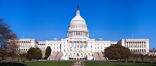
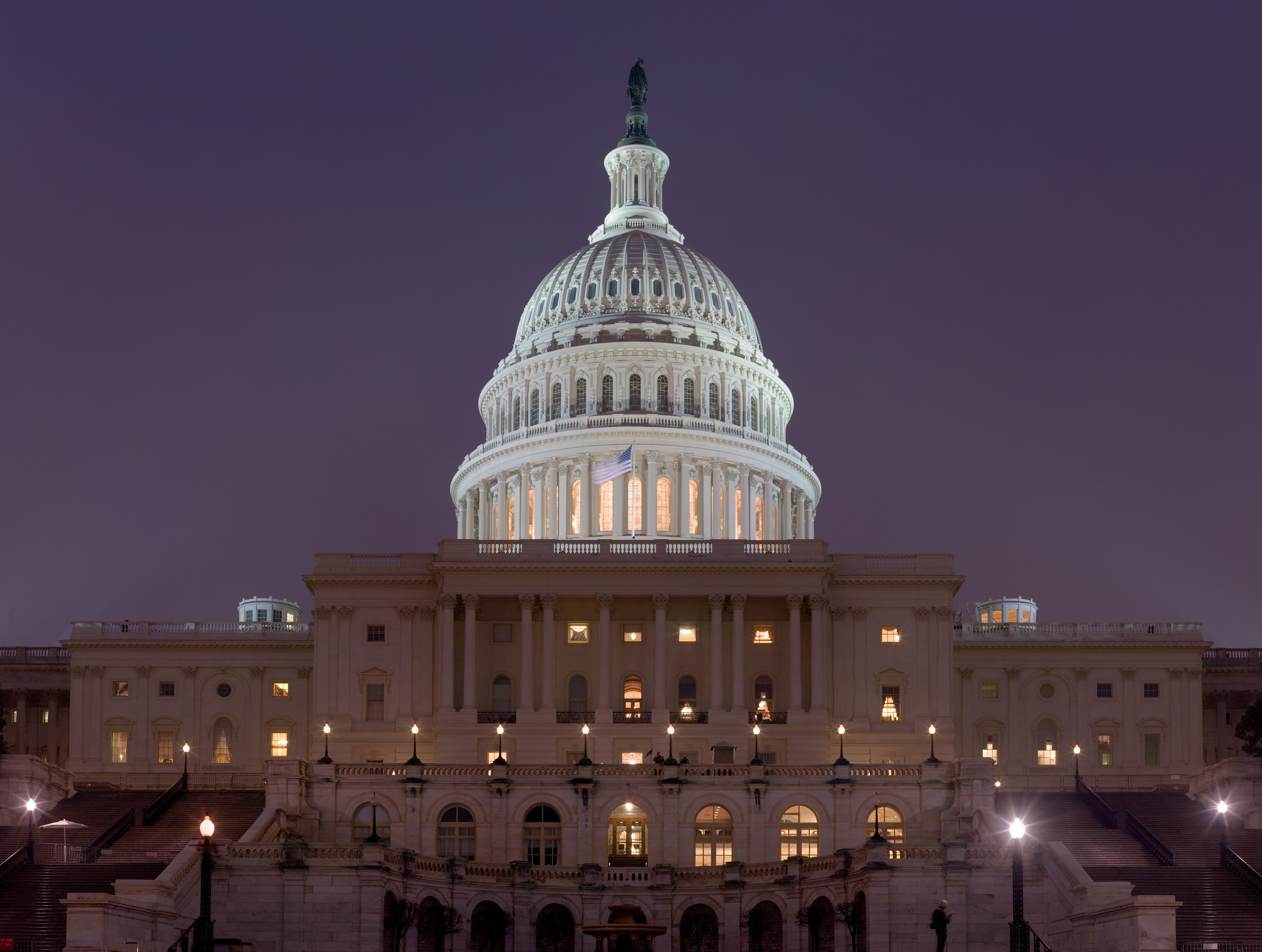
United States Capitol
The western (front) side of the United States Capitol. The U.S. Capitol serves as the location for Congress, the legislative branch of the U.S. federal government. It is located in Washington, D.C., on top of Capitol Hill at the east end of the National Mall. The building is marked by its central dome above a rotunda and two wings. It is an exemplar of the Neoclassical architecture style.
Saturday, October 24, 2009
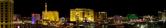
Las Vegas Strip
A panorama of a portion of the Las Vegas Strip at night (facing east), as seen from the Bellagio. Despite the name, the majority of The Strip is not actually within the city limits of Las Vegas, Nevada. Visible in the image are (left to right) Bally's, Paris, Aladdin (now Planet Hollywood), MGM Grand, Monte Carlo, New York-New York, the Project CityCenter construction site, as well as a number of other smaller hotels and casinos.

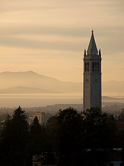
Sather Tower
Sather Tower on the campus of the University of California, Berkeley, as seen from California Memorial Stadium at sunset. The campanile (bell and clock tower), home of a full concert 61-bell carillon, serves as the school's most recognizable symbol and has been a major point of orientation in almost every campus master plan. The tower has thirteen floors, with the observation deck on the eighth.

Vernal Fall
Vernal Fall is a 317 ft (97 m) tall waterfall on the Merced River just downstream of Nevada Fall in Yosemite National Park, California, USA. It is accessible via the Mist Trail, which climbs close enough to the fall so that hikers must travel through the fall's mist. The waterfall runs all year long, although by the end of summer, it is substantially reduced in volume and can split into multiple strands, rather than a single curtain, of water.


Sunday, October 4, 2009
Alcatraz Island
A stitched panorama of Alcatraz Island, in San Francisco Bay, California, as seen facing east. Alcatraz is most famous for its prison, which closed in 1963, but whose legacy lived on in films such as Escape from Alcatraz and The Rock. Today it is a National Recreation Area


Friday, October 2, 2009
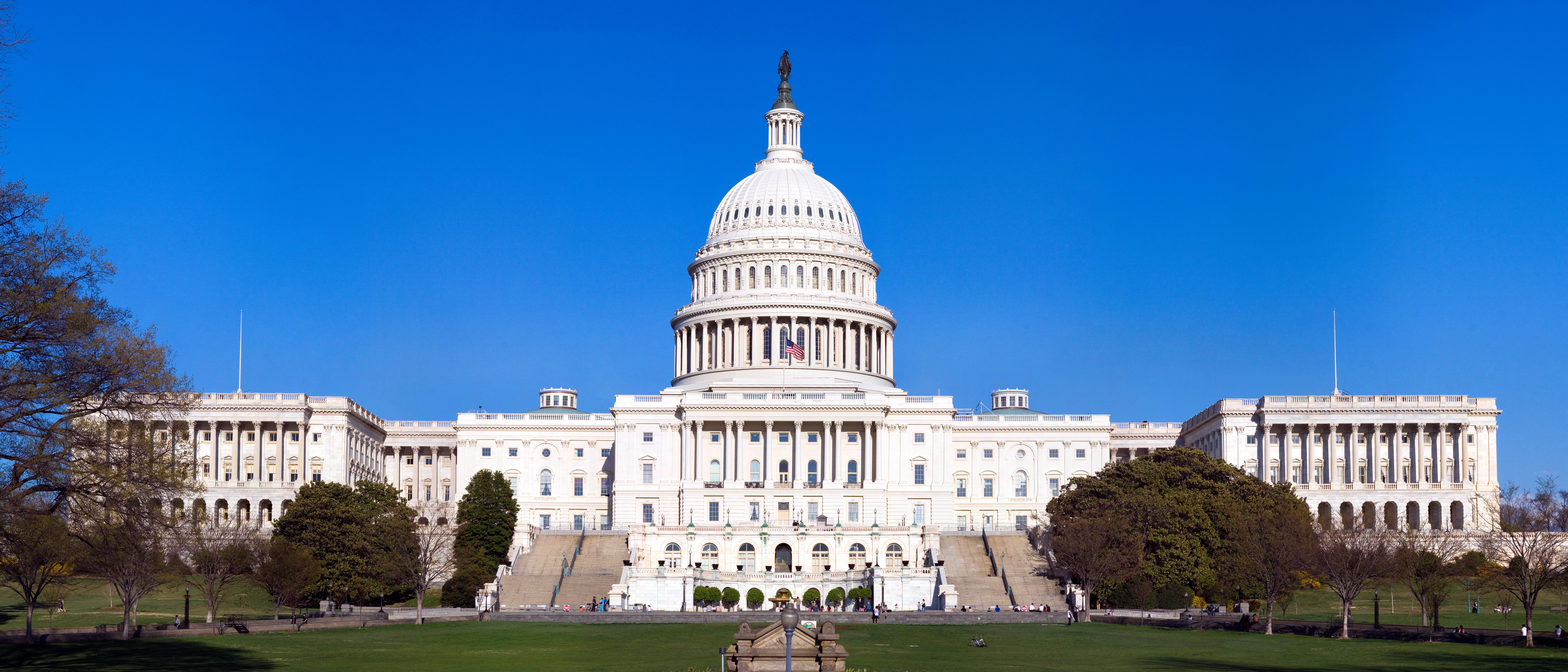
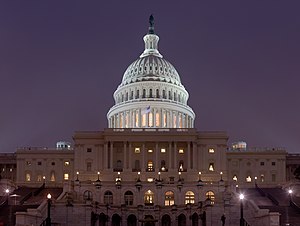
US Capitol Building
The United States Capitol at night. The U.S. Capitol serves as the location for Congress, the legislative branch of the U.S. federal government. It is located in Washington, D.C., on top of Capitol Hill at the east end of the National Mall. The building is marked by its central dome above a rotunda and two wings. It is an exemplar of the Neoclassical architecture style.
Monday, September 28, 2009
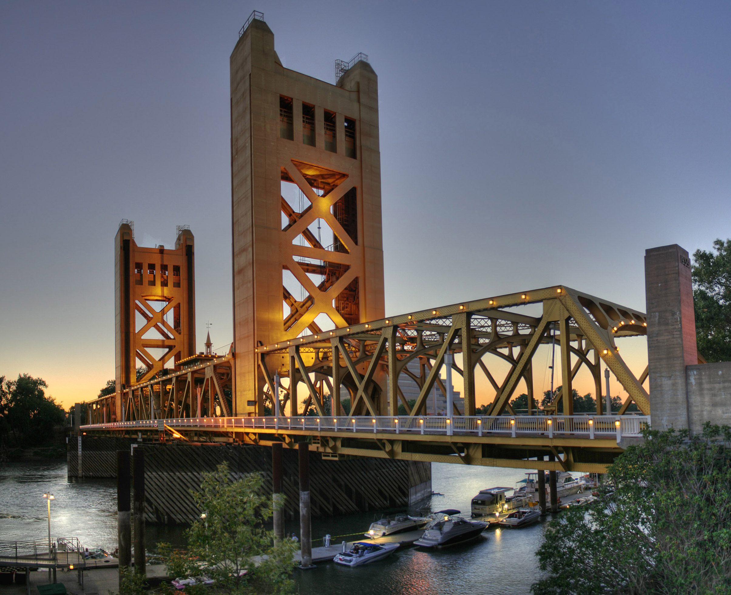
Tower Bridge, Sacramento, California, USA
An HDR image of Tower Bridge at twilight crossing the Sacramento River in Sacramento, California. Completed in 1935, this was the first vertical lift bridge in the California Highway System. It is 52 feet (15.8 m) wide, 737 feet (223.3 m) long, and 160 feet (48.5 m) tall. There are four lanes for cars, and one large center lane for a railroad.

Lower Manhattan skyline
Lower Manhattan (seen here from the Staten Island Ferry) is the southernmost part of the island of Manhattan, the main island and center of business and government of the City of New York. Lower Manhattan includes City Hall, the Municipal Building, the Financial District and the site of the World Trade Center. This area is also the earliest settled (by Europeans) area, and is one of the few areas of Manhattan that does not have its streets arranged in a strict grid pattern.


Mount Hood, Oregon
Mount Hood, a dormant stratovolcano, reflected in the waters of Trillium Lake, Oregon, United States. At 11,249 feet (3,429 metres), Mount Hood is the highest mountain in Oregon and the fourth-highest in the Cascade Range. It is considered an active volcano, but no major eruptive events have been catalogued since systematic record keeping began in the 1820s.


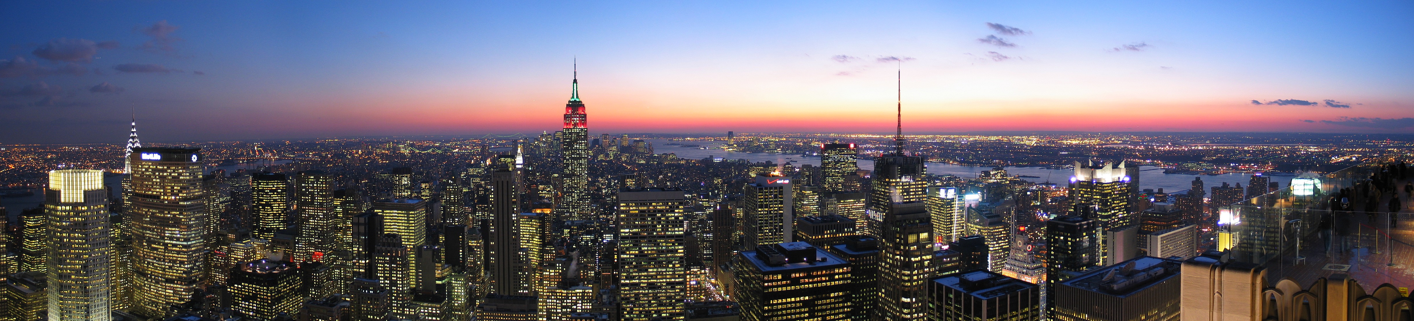
New York City
New York City, nicknamed the "Big Apple", is the most populous city in the United States (8.1 million in 2005) and the most densely populated major city in North America. The city is a center for international finance, fashion, entertainment, and culture, and is widely considered to be one of the world's major global cities. The city proper consists of five boroughs: The Bronx, Brooklyn, Manhattan, Queens, and Staten Island. The city is also distinguished for having the lowest crime rate among the 25 largest American cities.

Sunday, September 27, 2009
Main concourse, Grand Central Terminal, New York, NY, USA
Grand Central Terminal (often still called Grand Central Station) is a train station in Midtown Manhattan in New York City. It is the largest train station in the world by number of platforms: 44, with 67 tracks along them. The four-faced clock on top of the information booth in the center of the Main Concourse (shown here) is perhaps the station's most recognizable icon.


San Francisco International Airport at night
San Francisco International Airport (IATA: SFO) opened on May 7, 1927 on 150 acres (607,000 m²) of cow pasture leased from prominent local landowner Ogden L. Mills, and was named Mills Field Municipal Airport. During the economic boom of the 1990s and the dot com boom, SFO became the 6th busiest international airport in the world. However, since the boom times ended, it has fallen back out of the top twenty.


Looking at this pic gave me goosebump. How the Photographer clicked it..
Zion National Park is a United States National Park located near Springdale, Utah in the southwestern United States. The principal feature in the 229 square mile (593 km²) park is the 15 mile (24 km) long and up to half a mile (1 km) deep Zion Canyon, which was cut through the reddish and tan-colored Navajo Sandstone by the North Fork of the Virgin River. The geology of the Zion and Kolob canyons area includes nine formations that together represent 150 million years of mostly Mesozoic-aged sedimentation. At various periods in that time, warm, shallow seas, streams, ponds and lakes, vast deserts and dry near-shore environments covered the area.


Los Angels-A Panoramic View.
Los Angeles is the second-largest city in the United States, with an estimated population of 3.85 million people. Los Angeles is one of the cultural, economic, scientific and entertainment centers of the country. Due to the city's geography as well as the population's heavy reliance on automobiles as a major form of transportation, the city suffers from severe air pollution in the form of smog. The Los Angeles Basin and the San Fernando Valley hold in the fumes from automobiles, diesel trucks, shipping, and locomotive engines, as well as manufacturing and other sources.


The Golden Gate Bridge
The Golden Gate Bridge is a suspension bridge spanning the Golden Gate, the opening into the San Francisco Bay from the Pacific Ocean. The entire bridge including the approach spans is 1.7 miles (2727 m) long, whilst the main span between the towers is 4200 feet (1280 m). The two towers rise 746 feet (230 m) above the water. From its completion in 1937, the center span was the longest among suspension bridges until 1964 when the Verrazano Narrows Bridge was erected.


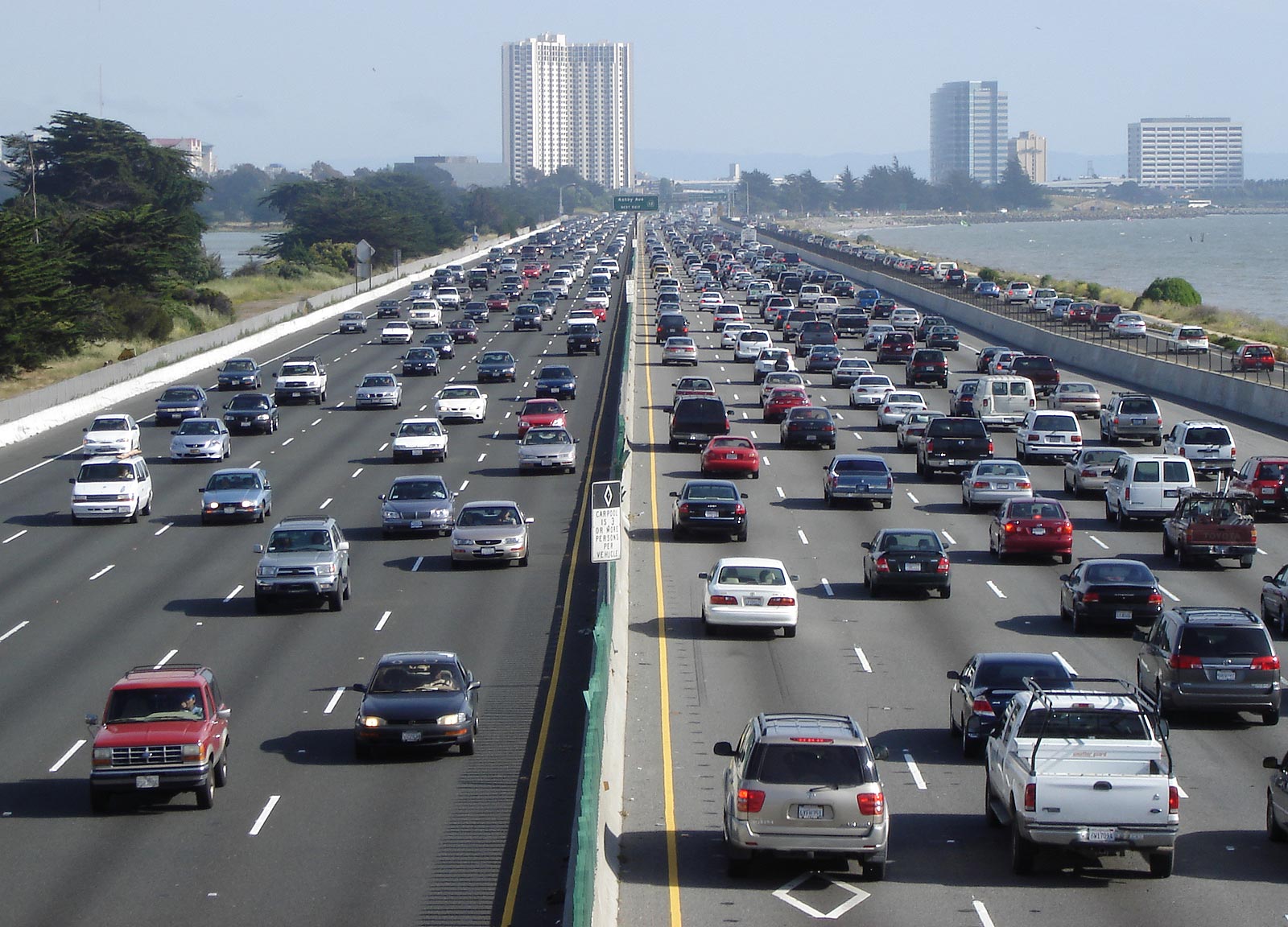
Freeway or Highway
A freeway is a multi-lane highway (road) designed for high-speed travel by large numbers of vehicles, and having no traffic lights, stop signs, nor other regulations requiring vehicles to stop for cross-traffic.
Interstate 80 is a major urban freeway through the East Bay, north of the Bay Bridge, in the San Francisco Bay Area (seen here in Berkeley, California).
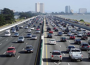
Interstate 80 is a major urban freeway through the East Bay, north of the Bay Bridge, in the San Francisco Bay Area (seen here in Berkeley, California).
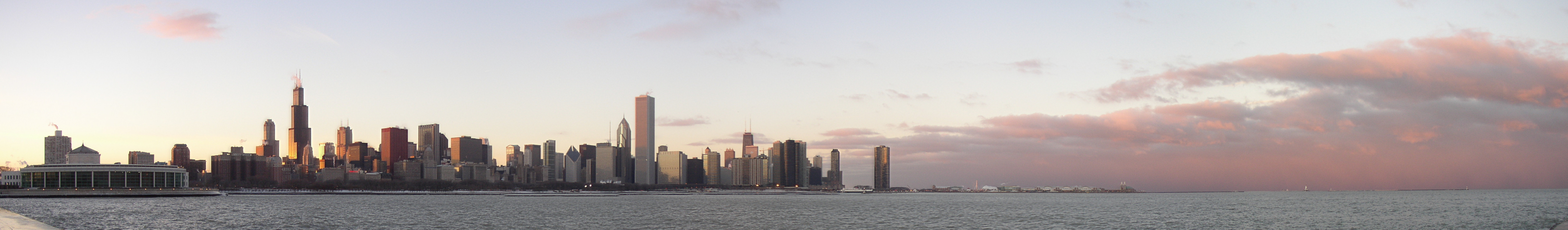
The skyline of the City of Chicago
The skyline of the City of Chicago seen from across Lake Michigan near the Adler Planetarium at dusk. Chicago is the third largest city in the United States (after New York City and Los Angeles), with an official population of 2.9 million.

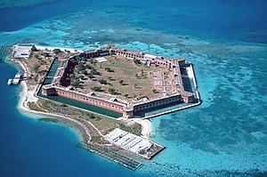
Fort Jeffersons
The Dry Tortugas are a small group of islands, located at the end of the Florida Keys, USA. As seen easily in the photo, the clear waters in shallow areas surrounding Fort Jefferson are popular for snorkeling and scuba diving. Visible on the right side of the image is a breach of the sea wall caused by the direct strike of Hurricane Charley in August 2004.

Sunday, September 13, 2009

Subscribe to:
Posts (Atom)